Also shown are the approximate location of the discovery of B. swaseyi along the Pedernales by Buckley in 1866 (area 1,  ); Purgatory (S. Hays) area visited by Plank in 1893 (area 2,
  ); Frio Waterhole – the westernmost area for B. swaseyi discovery c. 1897 by Hill & Vaughan (area 3,
  ); and the location of our property (Purola,
  ), immediately south of the Pedernales River and in the center of area 1 above.
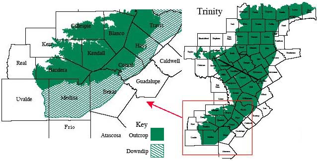
The map itself was adapted from Hill & Vaughan's 1898 Geology of the Edwards Plateau and the Rio Grande Plain adjacent to Austin and San Antonio, Texas, with reference to the occurrence of underground waters because it gives a clear picture of the Balcones Escarpment at the southeastern edge of the Edwards Plateau (map below). The above B. swaseyi populations are never far from this edge of the escarpment. Even more striking is their proximity to the southern third of the Trinity Aquifer (shown below). This may perhaps indicate both climate and type of drainage as limiting factors in the species' distribution.
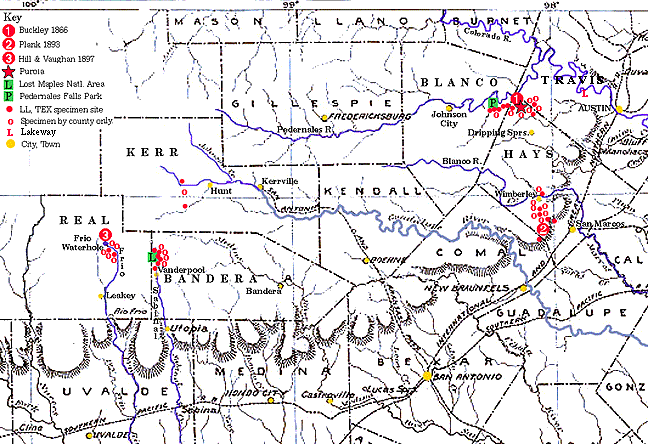
The distributional plots are based primarily on data from two online sources (U. Texas at Austin Plant Resources Center and Digital Flora of Texas Herbarium Specimen Browser). Solid red dots indicate those for which specific locations are given (for LL and TEX); dots with white centers had only counties given and were arbitrarily placed adjacent to the red dots. 'L' indicates the northernmost significant population (c. 30.35° N) at Lakeway, which I visited in July, 2006. (The general Lakeway development location was documented in 1973 by P. A. Amerson's specimen in BRIT/SMU.) Following Turner et al. (2003) I have ignored as dubious the specimens listed for Brewster Co. and Mississippi as well as a report from Bailey Co. in the Texas Panhandle. Two specimens said to have been collected by E. J. Palmer from Frio Co., south of Medina Co. and far from the Balcones Escarpment, have been interpreted as incorrect on the basis of a number of anomalies on the herbarium label, most significant of these being the location "East Fork of Frio River," which, however, lies entirely within Real Co. to the north of Medina Co. and an expected habitat for B. swaseyi.
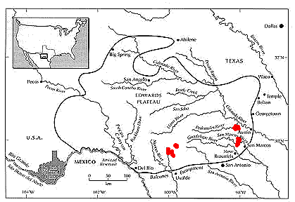
For a somewhat different perspective, although B. swaseyi is commonly said to be endemic to the Edwards Plateau it occupies only a small edge of that zone.
Compare the above distributions to the map of the entire Edwards Plateau (reduced from a Smithsonian Institution map).